
The Department of Environment, in a statement and interactive map, has outlined how its advice and recommendations on coastal setbacks were ignored in the planning process of several of the properties that sustained damage in last week’s destructive nor’wester.
The DoE and the National Conservation Council has repeatedly suggested that setbacks outlined in the planning regulations should not be determined by a standardised distance of a minimum of 50 feet, but rather on a case-by-case basis.
They have advised that all factors should be taken into account, “which contribute to the vulnerability of a particular location to wave action and coastal inundation”.
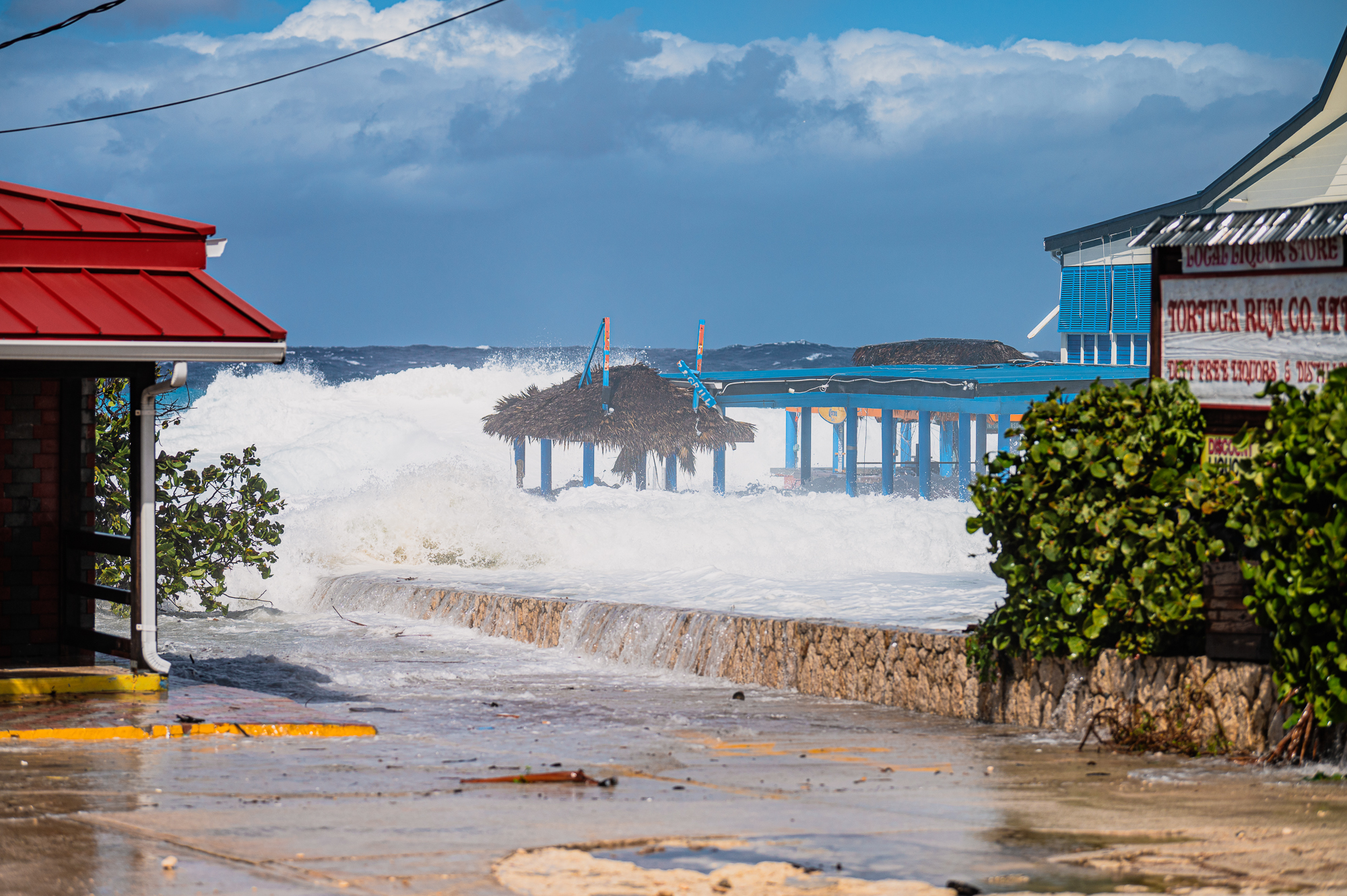
A nor’wester that blew through the Cayman Islands overnight on 5-6 Feb., bringing high seas and near-gale-force winds, damaged several residential and business properties along the west coast of Grand Cayman.
“Like many in our community, during and after the storm we received several photos and videos through social media depicting devastating damage to property, accompanied by questions about the vulnerability of building on the coast,” the DoE said in a statement issued on Friday evening.
This prompted the department to review the technical assessments it had provided to the Planning Department and the Central Planning Authority for a number of those developments.
“Our team of environmental and sustainability experts provide written technical assessments on a project basis to the originating entity, though the vast majority of these assessments are not legally binding, and are recommendations only,” the DoE noted.
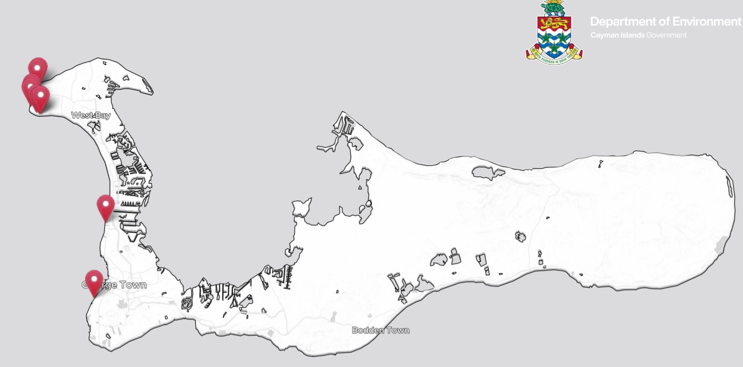
Interactive map
It created an interactive map, presenting the original technical reviews and how those reviews were incorporated, or not, into planning decisions related to coastal development, along with publicly circulated video clips and images showing what was experienced at those locations on 6 Feb.
“The results show how critically important it is to not generalise coastal setbacks but instead to take account of all factors which contribute to the vulnerability of a particular location to wave action and coastal inundation,” the DoE said.
“At a minimum, the following factors should be considered: coastal type, elevation, location in relation to windward or leeward sides of the island, the presence or absence of a shallow coastal lagoon fronted by a protective fringing reef and the presence of deep water close to shore.”
It added that until planning regulations are amended to include a coastal setback map that is based on consideration of these factors, “it is our sincere hope that the Ministry of Sustainability and Climate Resiliency’s proposal for a fixed coastal setback reference line along Seven Mile Beach based on long-term scientific data be considered for immediate implementation to help guide future developments”.
The DoE is also calling for a “consistent policy” to be applied by the planning officials of all proposed coastal development having to at least meet the currently specified minimum setbacks.
A draft Climate Change Policy, issued by government for public consultation in May 2023, included, as a short-term priority, a reassessment of the coastal setback reference line on all three islands and revision of coastal construction setbacks in the Development and Planning Regulations “to account for wave and storm surge flooding and sea level rise”.
That policy has not been finalised and no changes regarding climate change have been made to the Development and Planning Regulations.

Setback variations
Several of the planning applications that come before the Central Planning Authority include requests for variation on minimum coastal setbacks. Even ones that do adhere to the minimum setbacks are often opposed by the DoE, which over the years has outlined its concerns about individual coastline developments and the threats they are likely to face from the encroaching sea and inclement weather.
An example of this, highlighted in the DoE’s interactive map, is Lighthouse Point Residences on North West Point Road, West Bay, from which residents had to be evacuated in the early hours of 6 Feb., when ground-floor apartments were inundated with sea water as high waves smashed through the property.
When planning permission for that site was sought in 2017, the DoE’s recommendations stated, “The Department notes that the setback is met from the … standard mean high water mark but is not met from the sea pool which would now be the new high water mark.”
The department noted that the Central Planning Authority approved the application “without any record of the CPA’s consideration of the DoE’s comments”.
The DoE also noted that, in July 2019, it had opposed the granting of planning permission for the expansion of a deck at outdoor bar Macabuca, which was badly damaged in last week’s storm. It pointed out that the deck did not comply with the 50-foot minimum coastal setback laid out in the planning regulations.
The Central Planning Authority approved the application, stating that the outdoor bar, elevated deck and cabana were all located within the high water mark setback, and that the deck was an extension of the existing outdoor seating.
Next door to Macabuca, the proximity to the sea of a development currently under construction, called Sunset Point, was also opposed by the DoE during that planning application process in March 2021. This site was also badly flooded in last week’s nor’wester.
The DoE said at the time that a review of historical aerial imagery had shown that the vegetation line in this area had been set back at least 100-150 feet from the mean high water mark over several decades, “demonstrating the sea impact to the coastline”.
It recommended that the application be refused and the setbacks increased.
The Central Planning Authority disagreed with the DoE’s recommendation, stating that the majority of main buildings complied with the required setback and “it is only small portions and the ancillary features that do not”.
It added, “The applicant is also proposing a seawall and the Authority is of the view that the wall will provide sufficient protection for the buildings and ancillary features and the lesser setback will not detract from that protection.”
The DoE map also looked at the recommendations it had made in relation to FIN, a development on South Church Street, and included a video image of sea water lapping at a glass door at the premises during the storm. A number of waterfront properties, including Oceana and Kisha, on that stretch of road were impacted by last week’s weather.
During the planning application process for FIN, the DoE had “strongly recommended” that the proposed sea pools at the property be removed from the development plan and that the building setback be “significantly increased”.
The Central Planning Authority did make it a condition of its approval to delete the sea pools from the plan, but, noting that only a small portion of the building did not comply with the required 50-foot setback, it granted the setback variance requested by the applicant.
Related Videos


It would seem the Planning (?) Department has much to learn from the Environmental people! History has repeatedly shown that when it’s a contest between the Sea and the Dollar, the Sea always wins, and throwing more Money into the contest will always be a losing proposition!
The interactive map very well documented the DOE recommendations ( whose recommendations came true during the storm, no surprise ) and the Development Board responses ignoring the advice. The end result is that what DOE predicted came true and damage to structures that was predicted occurred. When with the Development Boards on Grand Cayman and Cayman Brac begin to seriously consider DOE recommendations for this and other environmental issues? Structures can and will be rebuilt at a cost but environmental recommendations cannot be rebuilt and will be lost forever.
Will they learn from their mistakes NOW??