
The National Hurricane Center has said tropical storm watches and advisories are likely to to be issued later on Wednesday as a weather system east-southeast of the Windward Islands becomes better organised.
“Environmental conditions appear generally favorable for continued development, and a tropical depression or storm is likely to form during the next day or two while the system moves west-northwestward at 20 to 25 miles per hour,” the NHC said in its midday report Wednesday.
Elsa would be the next named storm on the World Meteorological Organization’s Hurricane Committee list.
Hazard Management Cayman Islands, in a post in its official Facebook page, said although this area of low pressure is still several days away from presenting any potential threat (if any) to the Cayman area, “residents should monitor the Cayman Islands National Weather Service over the coming days as the cyclone (if it develops) moves into the Caribbean Sea”.
HMCI said, “In any event, residents are encouraged to have supplies of non-perishable food and a gallon of water per person per day (to last 5 days) during hurricane season, along with a plan for sheltering if their home is vulnerable to storm surge and other threats associated with hurricanes.”
The tropical disturbance is currently located in the Atlantic Ocean and continuing to track quickly west-northwestward towards islands in the Eastern Caribbean, HMCI said.
Cayman’s National Weather Service is expected to issue a tropical outlook at 4pm.
In its 1pm report, NWS said weather conditions associated with this system are expected to influence the Cayman area from next Monday morning through Tuesday evening.
“With this system being more active, the Cayman area may experience a little more adverse weather conditions along with fresh winds and rough seas,” it added.
Interests in the Lesser Antilles should closely monitor the progress of this system, as advisories on a potential tropical cyclone, accompanied by tropical storm watches for portions of the area, are likely to be issued, the NHC report stated.
The weather system has been upgraded to a 70% chance of formation through 48 hours and 90% chance through five days.
“Showers and thunderstorms associated with a broad low pressure area and tropical wave located about 1300 miles east-southeast of the Windward Islands have become better organized since yesterday,” the NHC said.
However, it added that recent satellite wind data indicates that the disturbance does not have a well-defined circulation.
Meanwhile, a second system which was also being monitored has all but dissipated.
The NHC said showers and thunderstorms continue in association with a tropical wave located over the Lesser Antilles.
“This system has become less organized since yesterday, and significant development is no longer expected while it moves quickly westward across the Caribbean Sea. The wave should continue to produce locally heavy rains over portions of the Lesser Antilles through tonight,” it added.
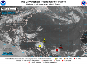
Original story: Forecasters have projected that in the Atlantic basin a broad area of low pressure, which is associated with a tropical wave, will become a tropical depression in the coming days.
The National Hurricane Center in Miami, in its morning report Wednesday, upgraded its forecast for the area of low pressure, one of two weather systems churning in the Atlantic basin.
In a Facebook post Tuesday night, Hazard Management Cayman Islands said of the system: “Larger wave forms [are] posing [a] rain threat” to parts of the Eastern Caribbean in the coming days.
Beyond that, HMCI said Cayman forecasters are still in a “watch [and] wait mode”, adding that Cayman residents should “adjust to increased tropical weather rain and thunder as summer progresses”.
In its report today, the NHC advised interests in the Windward and Leeward Islands to closely monitor this system as it will likely be moving through that region on Friday.
The system has been given a 60%, or medium, chance of formation through 48 hours and a 80%, or high, chance through five days.
The area of focus is located about midway between the west coast of Africa and the Windward Islands and is producing a large area of showers and thunderstorms, the NHC said.
The system, it added, continues to show signs of organisation.
“Environmental conditions appear generally favorable for development, and a tropical depression is likely to form during the next few days while the system moves west-northwestward at about 20 miles per hour,” the NHC said.
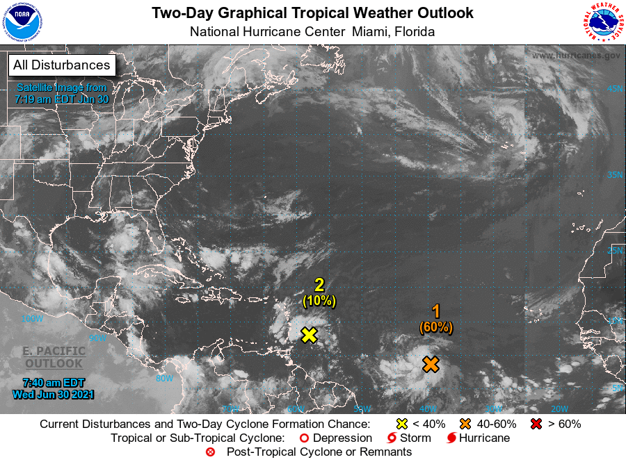
Meanwhile the NHC said significant development of a tropical wave located just east of the Lesser Antilles is unlikely while it moves quickly westward to west-northwestward at 20 to 25 miles per hour, passing through the Lesser Antilles Wednesday and then across the eastern and central Caribbean Sea later this week.
Although it has a low chance of formation, the system is producing disorganised showers and thunderstorms.
“Regardless of development, this system could bring locally heavy rainfall to portions of the
Lesser Antilles during the next day or two,” the NHC said.
The formation chance through the next five days has been pegged at 10%.
Related Videos


