
The Department of Environment has embarked on a one-year project to map the movement of Caribbean reef sharks and blacktip sharks in Cayman waters with the use of ‘pop-off’ satellite archival tags.
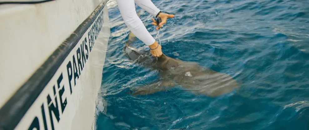
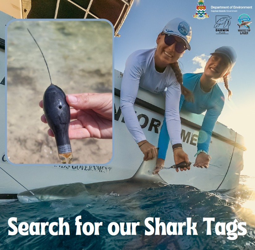
Eight out of ten ‘pop-off’ satellite archival tags or PSATs have already been attached to sharks in Cayman’s waters, a DoE statement on the project said on Tuesday. The tags are programmed to record data of the animals’ movements and help researchers better understand their behaviours.
The tags are programmed to “pop off” at timed intervals, float to the surface and wash back to shore.
Three of the tags have already popped off three of the sharks tagged in the project.
Johanna Kohler, a DoE shark project officer, has asked that anyone who finds the tags to contact the DoE to return them.
“We have received some preliminary data. If we retrieve the actual tag, we will be able to download even more data,” Kohler explained.
She told the Compass via email that data from the first tag that was retrieved showed that the mature Caribbean reef shark swam to a maximum depth of 340 meters with 18 degrees Celsius ambient water temperature.
“This is near to the maximum depth ever recorded for the species. The analysis of the time spent at specific depths and temperature ranges will give us a better understanding on the habitat, depth and temperature preferences of this species, which will be useful for other scientists to know as well,” she said.
The data, she said, will enable DoE to make predictions on how the species might change their behaviour in the face of climate change and increasing ocean temperatures, as well as “their role in connecting the shallow and deep water reef habitat, as part of the overall marine ecosystem around our islands”.
The data gathered throughout the project, Kohler said, will help the DoE “understand the ecological criteria needed to sustain the effective long-term survival of Caribbean reef sharks locally, while being subject to the effects of climate change and anthropogenic activities”.
Important conservation study
The project, which began in March 2024, is funded by a Darwin Plus Local grant of £48,385, about CI$51,600, from the UK government’s Biodiversity Challenge Funds, the Compass confirmed.
It is also being supported by the sale of White Tip Lager from Cayman Islands Brewery.
Kholer said at the end of this study, the new understanding of Cayman’s sharks will inform an action plan with ecological requirements that are key for the survival of this species locally.
The action plan will be presented to the National Conservation Council and communicated to the public.
Timothy Austin, DoE deputy director of research, said that the DoE looks forward to the “opportunities this project will provide, particularly for improving the conservation status of this locally important shark species”.
Kohler said the overarching aim of study is to collect “essential ecological information to improve our understanding of Caribbean reef sharks so we may better protect them and potentially other shark species in Cayman”.

The PSATs will help obtain “novel spatial and ecological data on the vertical habitat use and long-distance horizontal movements by the Caribbean reef shark in the Cayman Islands”, the DoE statement added.
In Cayman, the statement said, the knowledge gap on shark ecology paired with continued reports of dead sharks, despite proactive conservation efforts, “has raised concern about the effective protection of this species locally”.
Kohler stated that the problem is that Caribbean reef sharks rarely break the water surface, “so, to ensure data transfer, we decided to use pop-off satellite archival tags”.
Using PSATs, DoE’s shark research team, she said, will examine deep diving behaviour from the surface to a maximum survey depth of 1,400 meters.
Until recently, the DoE focused studies on shark ecology near the shore on the upper coastal shelf less than 30 meters deep, the statement said.
“This previous research using acoustic telemetry and baited underwater video (BRUV) surveys has revealed for the first time the wide-ranging nature of Cayman’s Caribbean reef sharks. This species was recorded to move long distances between our three islands,” it said.
The maximum distance recorded was 148.2 kilometers and “across abyssal depths/open ocean”.
“It is important for us to know about these migrations because this would mean that our sharks are potentially at risk of being exposed to fishing activities outside of our territory and this information would help facilitate regional species management and could support the Cayman Islands Government with marine boundary negotiations when the time comes,” Kohler said.
In 2022, as part of DoE’s research to map Cayman’s deep-sea environment, Caribbean reef sharks were recorded down to a depth of 200 meters.
“However, to date, higher resolution data on the (deep) diving behaviour, temperature ranges, and diel changes in vertical habitat use and long-distance horizontal movements by Caribbean reef sharks in Cayman have not been available,” it said.
How the project works
The DoE explained that the tags are attached to the first dorsal fin of the shark and will continuously record and archive depth, temperature and light-level data.
If you find the tags, contactShark Officer Dr. Johanna Kohler
This data can be used to then interpolate daily GPS locations from light-level geolocations.
The tags are expected to stay attached for a minimum of 2 months and maximum 5 months before their connections corrode at scheduled dates and the tags detach from the animals.
Detached tags will float to the surface and will start transmitting the stored data via a signal to earth-orbiting satellites.
In 2015, the Cayman Islands became the 10th nation to completely protect all shark species within national waters.
The animals are a protected species under the National Conservation Act (NCA, 2013).
Related Videos


