
Hurricane Beryl left a trail of destruction through the Caribbean but spared Cayman the worst of its wrath, leaving island residents both thankful and puzzled.
A storm of that size forming so early in the season was a record-breaking anomaly in itself.
The fact that it didn’t do more damage, while reassuring, raises questions about the nature of different hurricanes and their relative threat level to the islands.
With climate change and warming oceans in the mix, the possibility of bigger threats to come looms large in everyone’s minds.
World-renowned researchers Levi Silvers and Phil Klotzbach of Colorado State University’s Tropical Weather and Climate Research team, along with Simon Boxall of Cayman Islands Hazard Management, helped us get inside the cone of uncertainty and answer some of the key questions about Beryl and beyond.
Hurricane Beryl was a Category 3 storm that passed just 47 miles southwest of Grand Cayman. Shouldn’t we have expected more damage?
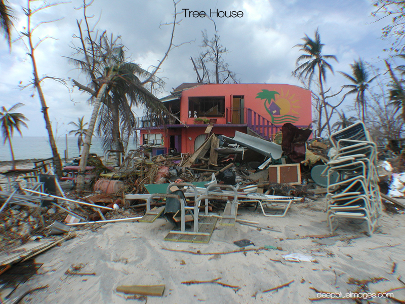
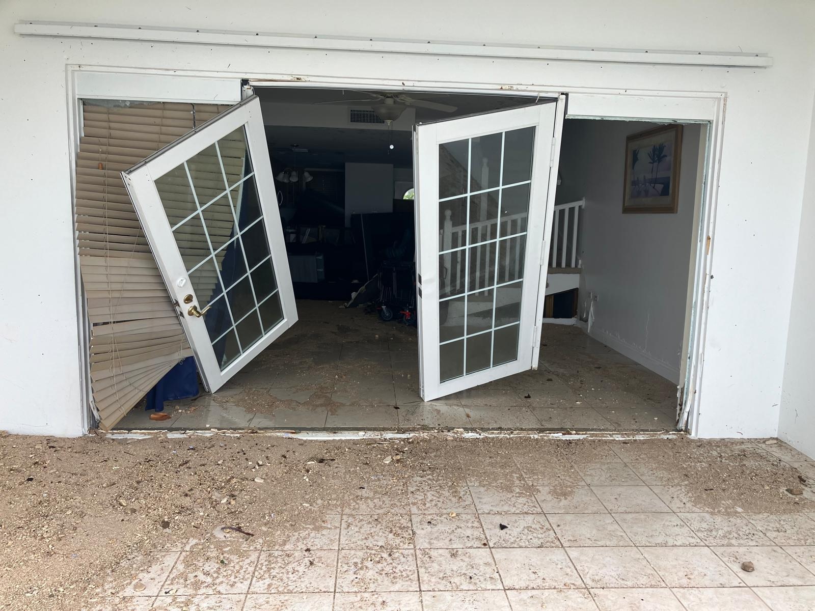
Hurricane Beryl left Cayman, for the most part, mercifully unscathed. The powerful storm had actually come closer than forecast but with the notable exception of Windsor Village, it did relatively little damage. For most, Tropical Storm Grace in 2021 was far more devastating.
Those with longer memories, like Hazard Management’s Simon Boxall, recall powerful storms passing much further away from the islands and doing far more damage.
So, why didn’t Beryl do more damage? The answer is relatively simple. It was a small storm.
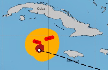
“While Beryl was a Cat. 3 hurricane when it tracked by Grand Cayman, the core of its hurricane-force winds stayed just offshore,” Klotzbach said.
“It was a pretty compact storm at this point.”
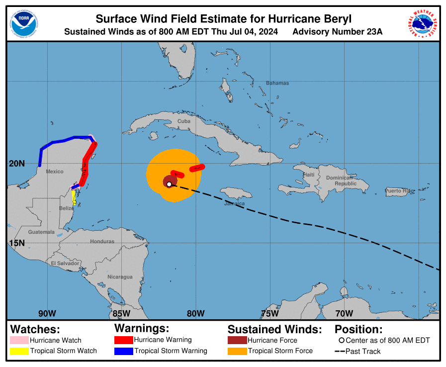
National Hurricane Center advisories indicate that hurricane-force winds extended only 45 miles from the centre as it passed Cayman.
“The centre of Beryl was just far enough offshore to spare Grand Cayman much more significant impacts,” Klotzbach said.
It is also worth noting that hurricanes come in different shapes and sizes. The categorisation system only factors in the strongest winds within a storm.
Some line up with the common conception – tight spirals like the @ sign on an email – with the strongest winds at the core. But many are asymmetrical.
Wild 7 day satellite study of Hurricane Beryl from Category 5 to tropical storm and then back to a hurricane! #Beryl #HurricaneBeryl pic.twitter.com/bF53zGW3Bz
— Rob Perillo (@robperillo) July 8, 2024
“A lot of times you’ll have it almost looks like the Milky Way,” Silvers said, describing how bands of thick rain can be unevenly distributed within a storm.
So did we dodge a bullet?
The simple answer to this is yes. But to extend the bullet analogy, this was one fired from a relatively small calibre weapon. It would have taken a sniper’s accuracy to cause the sort of devastation feared.
Beryl didn’t miss by much.
“All things considered, we are glad it wasn’t worse,” Silvers said.
“Imagine if it just barreled right into Haiti as a Category 5 or the Cayman Islands or even Jamaica took a nasty hit. It could have been worse in Jamaica if it veered to the north more.”
Could lesser category or more distant storms do more damage in the future?
Lesser category storms can and have done more damage in the past and will doubtless do so in the future. Equally, similarly powerful storms passing much further away have had far more impact.
Boxall recalls living on Little Cayman and seeing a nurse shark swimming on the road after Hurricane Gilbert passed far to the south in 1988.
“The waves were extraordinary and every boat on the island except one was lost,” he said.
“The front units of the Southern Cross Club were completely buried in sand to within a foot of the eaves. It looked like a normal beach but just the roof of the units was above the sand.”
Hurricane Mitch, a monster Category 5 storm, passed more than 200 miles from the Cayman Islands a decade later, but generated huge waves that did millions of dollars worth of damage to property.
What factors, beyond the category rating, influence a hurricane’s impact?
As discussed, the category of a storm depends purely on its wind speed.
The speed at which a storm moves, the amount of rainfall within it, the size of the hurricane-force wind field and the amount of surge it brings – something that depends on a combination of all those factors – influence its impact.
Speed is a double-edged sword. Hurricane Beryl passed by the Cayman Islands at a relatively brisk 20 miles per hour, which meant the duration of its effects was relatively contained. The flip side of that is, if other factors had aligned, that velocity could have compounded the wind speeds and increased the surge.
On the other hand, a storm like Hurricane Dorian in 2018 moved so slowly that it hovered over the Bahamas for days, meaning the islands were exposed to 185mph winds – a record for an Atlantic storm making landfall – for an extended period.
Klotzbach points out that storm surge, not wind, is the key threat from hurricanes.
“While hurricanes with stronger maximum sustained winds would tend to have more storm surge, another big driver is the size of the hurricane,” said the researcher, who advocates for hurricanes to be categorised by pressure instead of wind speed.
“The lowest pressure in a hurricane (e.g. in the eye) is a nice metric that by definition accounts for both storm intensity (e.g. wind) but also storm size.”
Even that would not quite tell the whole story, he acknowledges.
Boxall points to local geography and sea floor conditions as an indicator of how different types of storms might impact Cayman. Deeper water off the coast can lessen the surge impact but result in bigger waves. Coastal features, bays and sounds, as well as the exact angle of approach of the storm can have an impact.
Why is storm surge so dangerous?
While we tend to focus on wind speeds as the headline and category-making aspect of hurricanes, it is rarely the most deadly factor.
“One simple broad rule to keep in mind is that water kills people. Wind very rarely kills people,” Silvers said.
“All of us experience wind all the time. And so when that’s a little bit stronger, it can be very dangerous but it’s something we’re more familiar with.”
“If you have been in a region and lived on the coastline for a long time, you’re not used to a 10-foot wall of water coming in … . So much damage and so much death and destruction can come from the storm surge.”
Boxall wants people in Cayman to bear in mind that storm surge, at its worst, doesn’t simply impact the areas on the coastline.
“Low-lying inland areas are also vulnerable in certain hurricane scenarios,” he added.
Is Ivan the worst-case scenario for Cayman?
Hurricane Ivan looms so large in the memories of anyone who lived through it that it is difficult to conceive of a more dangerous storm.
But it is certainly possible.
Ivan was an upper level Category 4 storm with a maximum wind speed of 155mph when it passed 21 miles from Grand Cayman at the closest point of approach on 11 Sept. 2004.
That is at the upper end of what can be anticipated but by no means the limit.
US-based weather experts, using extensive new seabed mapping data, are in the process of feeding 100,000 possible storm scenarios into a simulator to create a detailed risk map for the territory.
Hazard Management will get that data later this year and Boxall believes it is almost certain to show that in extreme, low-probability scenarios, much higher storm surge – possibly approaching 20 feet – is possible.
“People have anchored to the experience of Ivan and cannot conceive of the possibility of anything being worse. It is simply beyond the realm of their imagination. Unfortunately that is not so,” he said, adding that the likelihood of that worst case scenario is low.
“Ivan was without doubt a formidable cyclone but the possibility does exist for a larger cyclone with higher wind speeds and, therefore, higher surge.”
Is climate change making hurricanes worse?
The impact of climate change on hurricanes is a controversial topic. There’s no evidence of an increasing number of cyclones globally. In fact, Kolzbach says, the numbers have gone down, with the caveat that the reduction is entirely concentrated in the Pacific.
Atlantic hurricanes have actually increased marginally. That dynamic, he says, is linked to the El Niño/La Niña phenomenon in the Pacific, which influences surface temperature in both oceans.
So the numbers don’t seem to be influenced by changes in the climate; however, there is evidence of more rapidly intensifying storms and storms that carry more rainfall, potentially making these extreme weather events more volatile.
Klotzbach’s team at Colorado State, in a research paper, noted an increase in Category 5 hurricanes and an increase in rapidly intensifying hurricanes, likely due to warmer ocean waters providing more fuel for storms.

There’s less certainty about rainfall because the historic data is not there, but he indicates that modelling simulations do project greater rainfall from hurricanes due to climate warming.
Why is this season expected to be so active for storms?
In some ways Beryl, which was a record breaker in terms of how early it formed, was a harbinger of things to come.
It gives a bit more confidence, Silvers says, that those early-season projections were accurate.
A lot of technical work goes into forecasting but the big factor this year is La Niña (Spanish for little girl, the opposite of El Niño or little boy) in the Pacific. La Niña brings colder temperatures to the Pacific and the inverse to the Atlantic.
It’s those warmer temperatures on this side of the world that provide the fuel for stronger storms.
“That’s why we forecast such an overly active season,” said Silvers, part of the Colorado State team that, along with NOAA, provides the benchmark season forecast.
“We felt very confident this would be an extremely active season,” Silvers said.
The CSU team upgraded its forecast further this week, warning that Beryl was likely the ‘harbinger of a hyperactive season’.
The forecast indicates that the 2024 season will virtually run the alphabet with 25 named storms in prospect including 12 hurricanes and six major hurricanes.
“It’s interesting to see it off to such an active start. And I think that helps us be more confident in the verification of that,” Silvers said.
Do we need a Category 6 designation for storms?
There is a movement in some corners of the scientific community to expand the Saffir-Simpson Hurricane Wind Scale, which ranks hurricanes from Category 1 with wind speeds of 74mph to Category 5 at 157mph or higher.
US researchers have proposed a new Category 6 for storms of 192mph and above. There have been none of that strength so far in the Atlantic, but a handful of storms in the Pacific including Typhoon Haiyan, which killed more than 6,000 people in the Philippines in 2013, and Hurricane Patricia, which reached a top speed of 215mph when it formed near Mexico in 2015, would fit the bill.
The Colorado State team is not convinced it’s necessary. Klotzbach argues for the pressure metric as a better way to assess the totality of a hurricane’s destructive potential.
Silvers adds that a Category 5 storm is already so devastating that it would serve little purpose to add a new upper limit
“One way to look at this is that beyond a certain point, the storm is as bad as it can get. And it’s just, ‘get out of the way’.”
What can people in low-lying communities do to meet the challenge?
The challenge of a ‘get out of the way’ strategy is that for people living in places like the Cayman Islands, there is nowhere to run.
While evacuation mandates for certain complexes may help, the entire island is technically coastal and low lying.
The good news is that, since Ivan, the building code has been significantly improved, and as was seen last week, the territory’s disaster management protocols are extremely well drilled. Cayman built back much stronger after Ivan but the potential down side to that is a socially divided threat map, with poorer communities in older buildings carrying the brunt of the risk.
Another factor is the continued development near the coast, alongside the loss of mangroves and deterioration of reefs, which may have debilitated the island’s natural storm barriers and flood run-off zones.
In general, Silvers believes society can and is adapting to the threats of hurricanes by building better and being better prepared. With forecasting becoming more precise and buildings more resilient, the scope to limit deaths and damage is greater than it ever was.
“The Cayman Islands are probably much better than a lot of other communities had dealing with tropical storms, he said.
“I think our society can handle hurricanes, we just need to be smart about how we do it.”
Related Videos


Outstanding article! So well researched and written! I agree that the current rating system is flawed. Hurricane ratings should be based on size and intensity of the wind field as well as total precipitation and not just maximum wind speeds.